How to read the ‘France Train+Bus’ maps?
🇫🇷 Voir la version française
Each mode of transport is represented by a colour: (click to reveal)
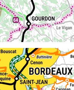
Stations listed in capital letters are served by long-distance trains.
➡️ See official rail maps for France
To reach other stations, you will need to take a regional train (TER).
In major cities, the exact name of the main station is specified (e.g. Bordeaux Saint-Jean).
🛤️ Train route planner (bahn.de)
🚲 Bicycle boarding rules (in French)
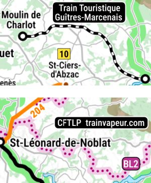
Lines served exclusively by tourist trains are indicated by a different symbol. They usually run only during summer time.
If a regular train line also carries a tourist train, only the name of the tourist train is shown.
The Train Jaune is a special case: it is a regular service operated by the SNCF, intended primarily for tourists.
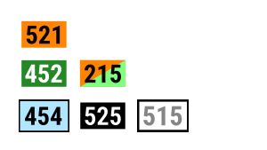
These bus routes are organised on a regional basis, but each often remains within a single département. Their numbers usually consist of three or four characters, with the first character indicating the département in question.
Line terminus label colours are used to indicate additional information:
Green: service allowing bicycles to be carried* all year round (service number written in green along the route)
Orange and green: route where bikes can be carried* only in summer
Blue: seasonal route (summer OR winter)
Black: seasonal route (summer AND winter)
White: route that does not run every day of the week (some run only once a week, in one direction only!)
🚲 * : on an external rack or in the luggage compartment. Some routes require a special booking. In some cases, boarding and alighting from the coach with a bike is only permitted at certain main stops: check the timetables.
On other routes, the driver may accept bicycles in the luggage compartment, although not being explicitly authorised.
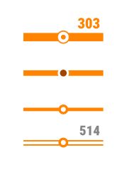
Regional and local bus routes drawn provide an overview of their frequency. This information is provided for guidance only: services vary considerably from route to route. Timetables always change at weekends and on public holidays, as well as during school holidays.
Thick line : Monday to Friday, there is at least one bus per hour in both directions. Most of these routes operate all year round, even on Sundays.
Medium line : On weekdays and during term time, these routes offer at least 5 services in each direction, evenly spread throughout the day (max 4 hours between each service): a frequency sufficient for a half-day excursion.
Thin line* : Routes with a minimum service, running at least once a day on weekdays.
Thin white line* : Routes running at least once a week during normal periods (service number written in gray along the route)
⚠️ A single line may offer different levels of service along its entire route.
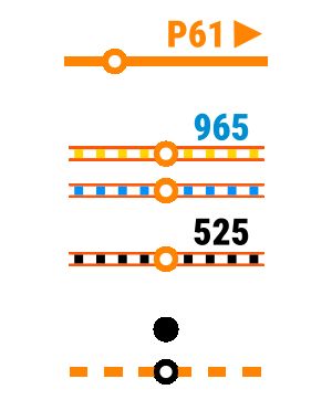
* : some of these routes have ‘asymmetrical’ timetables:
the arrow indicates that the P61 line only runs from left to right in the morning, and in the opposite direction in the afternoon and evening.
⚠️ A single route may be asymmetrical on just one section of its full route.
Some routes only operate during the tourist season. Their timetables are tailored to visitors:
Yellow dotted line: summer route
Blue dotted line: winter route
Black dotted line: summer and winter route
Villages accessible only by school transport open to the public (and therefore with a minimum and asymmetrical service) are indicated by a solid black dot.
Locations accessible via on-demand transport (TAD in French) are marked with a black circle. Some TAD services follow a predefined route (shown as an orange or grey dotted line if they do not run daily on weekdays).
These services must be booked in advance, usually on the previous working day. In some urban areas, same-day bookings are possible.
⚠️ TAD services reserved for local residents, people with reduced mobility, or those that run too infrequently, are not included.
➡️ To find your local TAD website, go to your Train+Bus map webpage and click on the ‘Resources’ tab
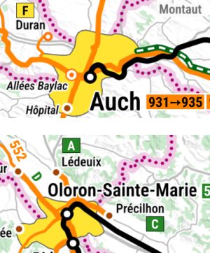
Some towns and cities have their own public transport networks. Their main routes run several times an hour, all year round, with frequent stops.
➡️ To access the urban network’s website, go to your Train+Bus map webpage and click on the ‘Resources’ tab
The area accessible via the local network is coloured yellow. Some lines extend beyond the urban area to serve neighbouring towns: these are shown as regional lines, but are marked with a square label on a yellow (or green) background at the terminus.
Major urban centres are often a terminus for many regional routes (e.g. Auch for routes 931 to 935). Where route codes are listed, the city is the terminus for all routes that serve it (Angoulême, Bordeaux, Toulouse, etc.)
‼️ A town’s coach main station is not always next to the railway station (Albi, Clermont-Ferrand, Tarbes, etc.). The stop for long-distance express coaches (such as Flixbus) is sometimes located further out of the town centre.
🚳 Local network buses generally do not accept bicycles (unless the line label has a green background, as is the case, for example, in Oloron-Sainte-Marie or Le Havre).
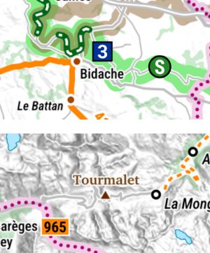
Cycle route routes are highlighted in green.
EuroVelo routes are identified by blue square markers bearing their number, ranging from 1 to 19.
Other cycle routes are marked by green circles: for their exact names, see the cycle routes list shown on the map.
The main greenways (with no motor traffic) are marked by an additional dark green symbol with white dotted lines.
Where this symbol is not shown, the cycle route follows a road with very little motor traffic.
ℹ️ The road network is shown in light grey.
⛰️ Road mountain passes are shown in brown.
⚠️ For the sake of clarity, only main cycle lanes in large urban areas and greenways significantly long are shown.
The trail numbers correspond to the GR® trails of the French hiking federation (FFRandonnée). ➡️ See the official website (in French)
GR® de Pays (GRP) trails do not have numbers, but have specific names (see the GRP list on the map). Some routes with different numbers and names may sometimes follow the same physical trail.
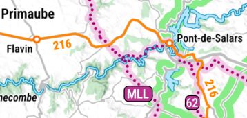
ℹ️ Particular attention has been paid to connections between footpaths and public transport stops: if a coach passes near a footpath, the absence of a stop on the map indicates that there is indeed no bus stop near the walk.
On the map shown here, there are no stops between Flavin and Pont-de-Salars. The GR® 62 and the Tour des Monts et Lacs du Lévézou can only be joined at Pont-de-Salars.